


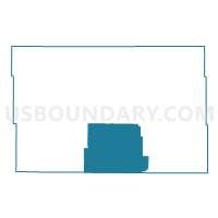
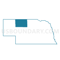
Wells Precinct, Cherry County, Nebraska
About
Outline

Summary
| Unique Area Identifier | 612579 |
| Name | Wells Precinct |
| County | Cherry County |
| State | Nebraska |
| Area (square miles) | 686.72 |
| Land Area (square miles) | 685.75 |
| Water Area (square miles) | 0.97 |
| % of Land Area | 99.86 |
| % of Water Area | 0.14 |
| Latitude of the Internal Point | 42.25763480 |
| Longtitude of the Internal Point | -101.05768010 |
Maps

Graphs
Select a template below for downloading or customizing gragh for Wells Precinct, Cherry County, Nebraska


Neighbors
Neighoring Voting District (by Name) Neighboring Voting District on the Map
- Gillaspie Precinct, Cherry County, NE
- Hooker Precinct, Hooker County, NE
- Kennedy Precinct, Cherry County, NE
- Lackey Precinct, Cherry County, NE
- Loup Precinct, Cherry County, NE
- Thomas Precinct, Thomas County, NE
Top 10 Neighboring County Subdivision (by Population) Neighboring County Subdivision on the Map
- Mullen precinct, Hooker County, NE (736)
- Thomas precinct, Thomas County, NE (647)
- Loup precinct, Cherry County, NE (233)
- Wells precinct, Cherry County, NE (129)
- Lackey precinct, Cherry County, NE (95)
- Kennedy precinct, Cherry County, NE (57)
- Gillaspie precinct, Cherry County, NE (43)
Top 10 Neighboring Unified School District (by Population) Neighboring Unified School District on the Map
- Valentine Community Schools, NE (4,515)
- Mullen Public Schools, NE (936)
- Thedford Public Schools, NE (561)
Top 10 Neighboring State Legislative District Upper Chamber (by Population) Neighboring State Legislative District Upper Chamber on the Map
Top 10 Neighboring 111th Congressional District (by Population) Neighboring 111th Congressional District on the Map
Top 10 Neighboring Census Tract (by Population) Neighboring Census Tract on the Map
- Census Tract 9559, Cherry County, NE (1,426)
- Census Tract 9567, Hooker County, NE (736)
- Census Tract 9571, Thomas County, NE (647)